FAIR is a non-profit organization dedicated to providing well-documented answers to criticisms of the doctrine, practice, and history of The Church of Jesus Christ of Latter-day Saints.
mNo edit summary |
mNo edit summary |
||
| Line 5: | Line 5: | ||
{| <!--Second table; can probably start any additional text below it--> | {| <!--Second table; can probably start any additional text below it--> | ||
|- | |- | ||
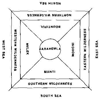
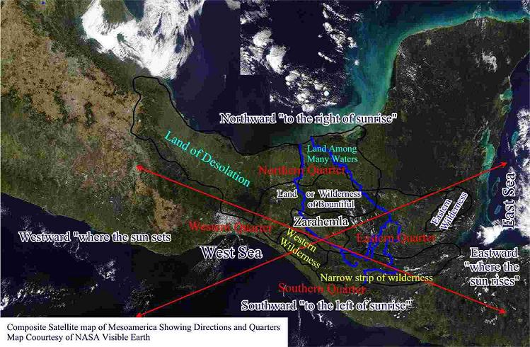
|Lawrence Poulsen, stimulated by the models proposed by Sorenson and Hauck, used his own study of the text, combined with advances in 3-D computer mapping technology and satellite maps to provide a fascinating refinement of the Mesoamerican model.{{ref|poulsen3}} <br> Poulsen compares Sorenson's River of Sidon suggestion (the Grijalva River) with Hauck's (the Usamacinta River) and finds Grijalva much more plausible.{{ref|poulsen1}} Poulsen extends this analysis to show how the explorers mentioned in {{s||Mosiah|8|7-10}} likely mistook Usamcinta for Sidon/Grijalva, thus becoming hopelessly lost. The Book of Mormon text is even accurate in the direction which the Sidon flows at a critical point.{{ref|poulsen2}} <BR> Furthermore, Poulsen suggests the use of a "quadrant"-based directional system as used by some Mesoamerican groups,{{ref|poulsen4}} as opposed to arguing that the Nephites used cardinal directions off-set from magnetic north, as Sorenson does.{{ref|sorenson5}} <br> Clark's review of Hauck contained a similar suggestion that the Nephites conceptualized their world in a quadrant-based fashion (see image at right). | |Lawrence Poulsen, stimulated by the models proposed by Sorenson and Hauck, used his own study of the text, combined with advances in 3-D computer mapping technology and satellite maps to provide a fascinating refinement of the Mesoamerican model.{{ref|poulsen3}} <br> Poulsen compares Sorenson's River of Sidon suggestion (the Grijalva River) with Hauck's (the Usamacinta River) and finds Grijalva much more plausible.{{ref|poulsen1}} Poulsen extends this analysis to show how the explorers mentioned in {{s||Mosiah|8|7-10}} likely mistook Usamcinta for Sidon/Grijalva, thus becoming hopelessly lost. The Book of Mormon text is even accurate in the direction which the Sidon flows at a critical point.{{ref|poulsen2}} <BR> | ||
For the Hill Cumorah, Poulsen suggests a hill Tepetzintla, located on the coastal plain to the west of the North-South-oriented coast of the Gulf of Mexico near the city of Tampico, Mexico. Interestingly enough, Tepetzintla translates to ''Cerro de Maiz'' in Spanish or "Corn Hill" in English, which is the translation of the Hill "Shim" (the Jaredite hill identified by the Nephites as "Cumorah"). | |||
Furthermore, Poulsen suggests the use of a "quadrant"-based directional system as used by some Mesoamerican groups,{{ref|poulsen4}} as opposed to arguing that the Nephites used cardinal directions off-set from magnetic north, as Sorenson does.{{ref|sorenson5}} <br> Clark's review of Hauck contained a similar suggestion that the Nephites conceptualized their world in a quadrant-based fashion (see image at right). | |||
<br> | <br> | ||
<br> | <br> | ||
| Model Name | Date Proposed | Scope | Narrow Neck | Land North | Land South | Cumorah | River Sidon | Nephi's Landing | Religion | Type of model
Model name: Poulsen 2004Date proposed: 2004 |
|---|
| Lawrence Poulsen, stimulated by the models proposed by Sorenson and Hauck, used his own study of the text, combined with advances in 3-D computer mapping technology and satellite maps to provide a fascinating refinement of the Mesoamerican model.[3] Poulsen compares Sorenson's River of Sidon suggestion (the Grijalva River) with Hauck's (the Usamacinta River) and finds Grijalva much more plausible.[4] Poulsen extends this analysis to show how the explorers mentioned in Mosiah 8꞉7-10 likely mistook Usamcinta for Sidon/Grijalva, thus becoming hopelessly lost. The Book of Mormon text is even accurate in the direction which the Sidon flows at a critical point.[5] For the Hill Cumorah, Poulsen suggests a hill Tepetzintla, located on the coastal plain to the west of the North-South-oriented coast of the Gulf of Mexico near the city of Tampico, Mexico. Interestingly enough, Tepetzintla translates to Cerro de Maiz in Spanish or "Corn Hill" in English, which is the translation of the Hill "Shim" (the Jaredite hill identified by the Nephites as "Cumorah"). Furthermore, Poulsen suggests the use of a "quadrant"-based directional system as used by some Mesoamerican groups,[6] as opposed to arguing that the Nephites used cardinal directions off-set from magnetic north, as Sorenson does.[7] |
 |
 |

FAIR is a non-profit organization dedicated to providing well-documented answers to criticisms of the doctrine, practice, and history of The Church of Jesus Christ of Latter-day Saints.
We are a volunteer organization. We invite you to give back.
Donate Now